Official Website
21164 Steptoe Hill Rd. Middleburg, VA 20117-3136
Telephone: 540-687-6262
Observing Field Coordinates: 39° 01′ 57″, -77° 41′ 45″
Elevation: 141 m.
Decimal Equivalents (Google Maps/Earth) 39.032375, -77.695839
What 3 Words navigator app, https://what3words.com ///circulation.contour.pampering
Coordinator: NOVAC Member Volunteer needed
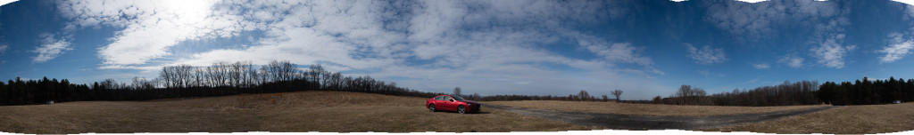
Panorama by Chris Kagy
Camp Highroad (CHR) is a Methodist Church camp north of Middleburg, VA. NOVAC has enjoyed use of the site continuously for over 25 years. The observing area is at the highest point in camp, on top of a ridge with unobstructed views north and west, a tree line due east at about 20 degrees elevation, and a tree line due south at about 10 degrees elevation. So the site has close to 360 degree panoramic views.
One of the main benefits of CHR is that NOVAC has unrestricted access, year-round use of the site. We’ll update this page with any restricted dates should those occur.
There are tenants who rent from CHR and use the meadow for various purposes. This area is surrounded by an electric fence but there is plenty of room for cars, observers, and equipment without the need to venture too close to the fence. Some years the area is farmed for hay. In past years it has been fenced for horse grazing or fenced for cattle pasture. On occasion the grazing animals manage to get out of the fenced area, so be aware of that possibility but we’ve never had any reports of aggressive behavior or roaming near expensive telescope equipment, PCs, cameras and other electronics.
NOVAC pays for the porta-john at the bottom of the hill next to the road, you pass it on the right as you climb the last bit to the top of the ridge. It’s 100 yards or so of a walk.
Restrictions on NOVAC use of CHR:
No camping or campfires are allowed on the site. NOVAC members are allowed to spend the night but please sleep in your car (no tents) if you are making an all-night imaging run or waiting for skies before dawn. Please dim to your amber running lights approaching the top of the hill after dark and turn them off when you near the top of the ridge. Best, as with most of our sites, to drive there in daylight for your first visit. Send a note to members@m.novac.com if you plan to visit CHR and especially if you plan to sleep in your car. As with all NOVAC observing sites refrain from the use of loud radios and alcoholic beverages. Loose, roaming pets are also not allowed. On departure please clean the area of all litter.
Enjoy your observing at Camp Highroad!
Directions:
Access to Camp Highroad from the Washington Metro Area presumes you can navigate to the intersection of Battlefield Parkway and US-15 south of Leesburg, or, the roundabout at the intersection of US-50 and US-15 near Aldie traveling west towards Middleburg. Both sets of directions take you to the east and west terminus of Lime Kiln Road (County Road 733) respectively in Loudoun County. Access to the Camp Highroad observing site takes you to a small mountain ridge near Goose Creek.
From Northern Virginia, DC and the Capital Beltway including Central and Southern Fairfax County. Best access, westbound I-66 and US-50 to Middleburg:
US-50 west towards Middleburg, VA to the roundabout, intersection of US-15 and US-50 near Aldie. Continue west 1.7 miles on US-50 through the small village of Aldie (watch your speed – 25 mph). Leaving Aldie, turn right on Snickersville Turnpike, County Road 734. Drive north 4.6 miles. Turn right onto the western terminus of Lime Kiln Road, County Road 733. In 0.9 miles turn left on to Steptoe Hill Road, a stone-chip road that climbs the mountain to the camp entrance. Follow the directions below once on Steptoe Hill Road.
From Loudoun County including Leesburg, Ashburn, Sterling and Northern Fairfax County including Herndon, Reston and Tysons Corner. Best access, the Dulles Toll Road and Greenway, or the Leesburg Bypass, then south on US-15 towards Warrenton:
US-15 heading south leaving Leesburg or the Leesburg Bypass. At the intersection of Battlefield Parkway and US-15, drive south another 5 miles on US-15. Turn right onto the eastern terminus of Lime Kiln Road, County Road 733. Follow Lime Kiln 4.7 miles west. Turn right onto Steptoe Hill Road, a stone-chip road that climbs the mountain to the camp entrance. Follow the directions below once on Steptoe Hill Road.
Entrance to CHR and the observing area from the intersection of Lime Kiln Road and Steptoe Hill Road:
Climb the stone chip road 0.6 miles to the entrance of Camp Highroad, turn left at the sign. If traveling in daylight, pass a small pond on your right, and then a white farmhouse. Continue on the road through the woods. In about a quarter mile, the road emerges from the woods, passes a porta john on the right (we are allowed access), and climbs the last few hundred feet in an open meadow to the top of the ridge. Our observing area is at the top of the ridge on the left-hand side of the road. Please back your car into the observing area perpendicular to the road to allow the most room for other visitors. Setup your gear behind your car.
You must be logged in to post a comment.